PV- und windanlagen auf deiner fläche planenplan PV and wind plants on your site
zeichne deine fläche auf der karte oder importiere sie. ready-to-connect layout berechnet mögliche anlagenanordnungen und zeigt dir leistung, erwarteten ertrag und den bedarf an wegen und kabeln.draw your site on the map or import it. ready-to-connect layout calculates possible plant arrangements and shows you capacity, expected yield and the roads and cables required.
deine vorgaben bestimmen die anordnung.your inputs determine the arrangement.
01
fläche und ausschlussflächensite and exclusion areas
als KML, KMZ oder GeoJSON importiert oder direkt auf der karte gezeichnet. ecken lassen sich nachträglich verschieben.imported as KML, KMZ or GeoJSON, or drawn directly on the map. corners can be moved afterwards.
02
komponentencomponents
bei PV modultyp, unterkonstruktion, wechselrichter und kabelquerschnitt, beim wind anlagentyp und nabenhöhe. ein katalog mit herstellerangaben ist mitgeliefert.for PV: module type, mounting structure, inverter and cable cross-section; for wind: turbine type and hub height. a catalogue with manufacturer data is included.
03
planungsregelndesign rules
randabstand, reihenabstand, bodenfreiheit und fahrwege bei PV; beim wind das abstandsrecht des landes und die schutzobjekte in der umgebung.edge setback, row spacing, ground clearance and access roads for PV; for wind, the state's setback rules and protected objects in the surroundings.
das ergebnisthe result
so sieht deine planung aus.this is what your layout looks like.
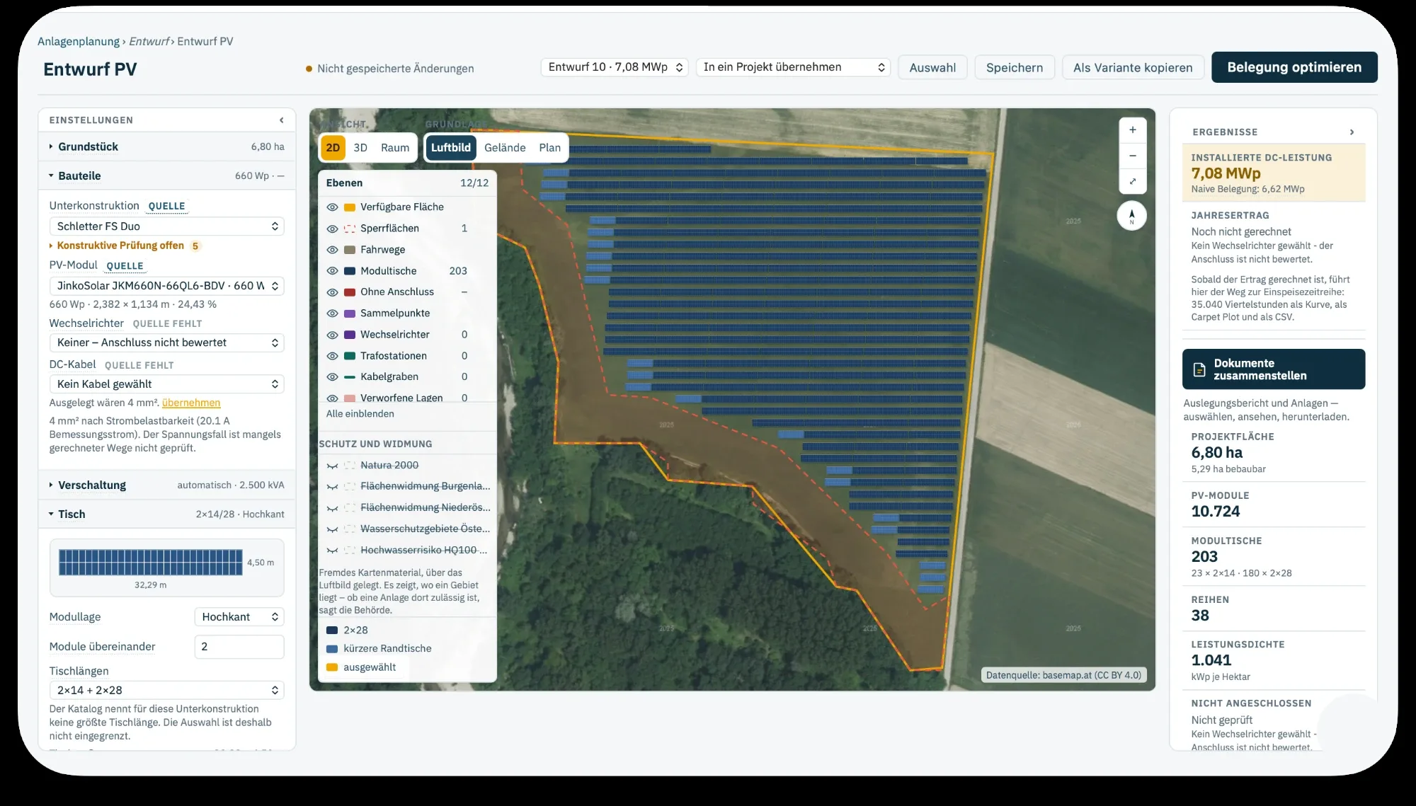
entwurf einer freiflächenanlagedraft of a ground-mounted PV plant7,08 MWp auf 6,80 hektar, 10.724 module auf 203 tischen, 1.041 kWp je hektar7.08 MWp on 6.80 hectares, 10,724 modules on 203 tables, 1,041 kWp per hectarebeispieldatensample data
01
leistung und ertragcapacity and yield
die installierte leistung ergibt sich aus der anordnung auf der fläche. dazu der erwartete jahresertrag, stundenweise über ein typisches wetterjahr gerechnet.installed capacity follows from the arrangement on the site, plus the expected annual yield, calculated hour by hour over a typical weather year.
02
wege und kabelroads and cables
die planung zeigt die benötigten zufahrten und kabelverbindungen. die auswertung nennt kabelbedarf und berechnete leitungsverluste, dazu einen vorschlag für den querschnitt.the layout shows the access roads and cable connections required. the analysis states cable demand and calculated line losses, plus a suggested cross-section.
03
flächen ohne anlageareas without plant
flächen, auf denen wegen gelände, abstand oder sperrfläche keine anlage platziert werden konnte, bleiben auf der karte sichtbar. damit ist erkennbar, an welcher stelle die fläche leistung kostet.areas where no plant could be placed because of terrain, setbacks or exclusion zones remain visible on the map, so you can see where the site is costing you capacity.
04
weiterverwendenreuse
die planung lässt sich als geodaten ausgeben und einem projekt in ready-to-connect develop zuordnen, das dann mit dieser leistung und diesem ertrag rechnet.the layout can be exported as geodata and assigned to a project in ready-to-connect develop, which then calculates with this capacity and yield.
wir zeigen dir in der demo, wie du anlagenvarianten auf einer fläche vergleichst.in the demo, we show you how to compare plant variants on one site.
eine planung lässt sich mit allen einstellungen duplizieren und als variante weiterrechnen. drei vergleiche sind eingebaut.a layout can be duplicated with all settings and developed further as a variant. three comparisons are built in.
PV-bauartenPV mounting types
pult, ost-west und tracker.fixed tilt, east-west and tracker.
alle drei bauarten lassen sich auf derselben fläche rechnen. die auswertung zeigt je bauart, wie viele tische passen, welche leistung daraus folgt und was sie im jahr erwartbar erzeugt.all three mounting types can be calculated on the same site. for each type, the analysis shows how many tables fit, the resulting capacity and the expected annual generation.
windabständewind setbacks
die vorgaben des bundeslandsthe state's requirements
der mindestabstand zu wohnbebauung, straßen und schutzobjekten steht im regelwerk mal als fester wert, mal als vielfaches der anlagenhöhe. bei einer großen anlage liegen die ergebnisse weit auseinander. hinterlegt sind 16 deutsche und 9 österreichische länder, und an jedem wert steht, worauf er sich stützt: gesetz, verordnung, landesplanung, empfehlung oder annahme.the minimum distance to housing, roads and protected objects is set sometimes as a fixed value, sometimes as a multiple of turbine height. for a large turbine, the results differ widely. all 16 german and 9 austrian states are covered, and each value states its basis: law, ordinance, state planning, recommendation or assumption.
01
reihenabstände in einem zugrow spacings in one go
bis zu zehn reihenabstände nebeneinander, mit leistung, kWp je hektar und der angabe, ob die reihen sich verschatten. ein klick übernimmt den reihenabstand einer zeile in die planung; danach wird sie einmal vollständig gerechnet.up to ten row spacings side by side, with capacity, kWp per hectare and whether rows shade each other. one click applies a row spacing to the layout, which is then fully recalculated once.
02
windparkvariantenwind farm variants
anlagentyp und nabenhöhe bestimmen, wie viele anlagen auf die fläche passen: der abstand zu den nachbaranlagen folgt aus dem rotordurchmesser, der abstand nach außen teilweise aus der gesamthöhe.turbine type and hub height determine how many turbines fit on the site: spacing between turbines follows from rotor diameter, the outer setback partly from tip height.
03
in drei ansichtenin three views
draufsicht, schrägsicht und eine maßstabsgetreue 3D-ansicht mit geländemodell, in der die sonne nach datum und uhrzeit steht. zwölf kartenebenen lassen sich einzeln schalten, dazu je nach ort die schutzgebiets- und widmungsebenen der länder.top view, oblique view and a true-to-scale 3D view with terrain model, with the sun positioned by date and time. twelve map layers can be toggled individually, plus the states' protected-area and zoning layers depending on location.
windparkwind farm
anlagen setzen, flächenbedarf beziffernplace turbines, quantify land use
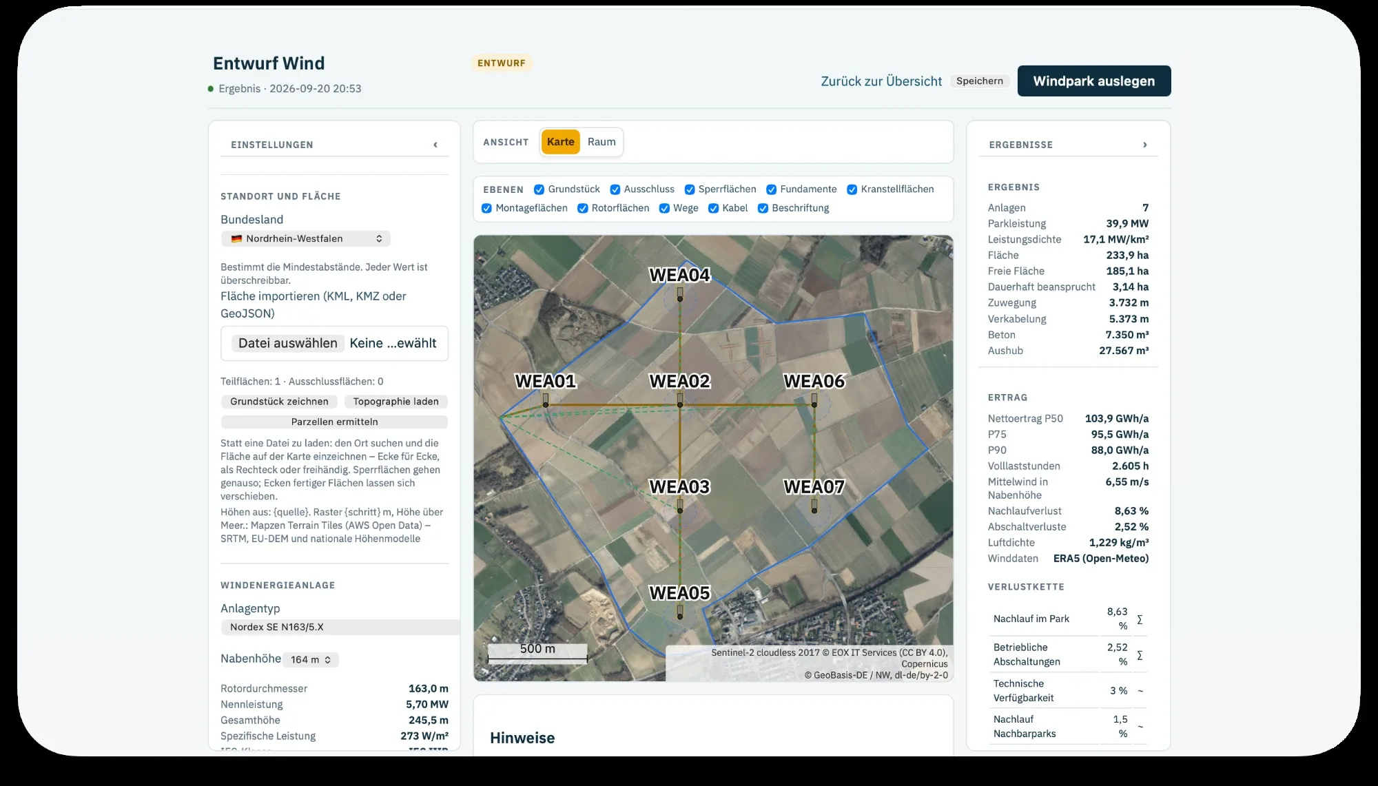
entwurf eines windparksdraft of a wind farm7 anlagen mit 39,9 MW auf 233,9 hektar, 103,9 GWh nettoertrag als P507 turbines with 39.9 MW on 233.9 hectares, 103.9 GWh net yield at P50beispieldatensample data
01
flächenbedarf für bau und betriebland use for construction and operation
je anlage werden fundament, kranstellfläche und montagefläche ausgewiesen, mit der angabe, ob die fläche dauerhaft beansprucht wird oder nur während der errichtung. daran hängen ausgleichsbedarf und pachtzins.for each turbine, foundation, crane pad and assembly area are shown, stating whether the land is used permanently or only during construction. compensation needs and lease payments depend on this.
02
zufahrten und kabelaccess roads and cables
die planung zeigt die benötigten zufahrten vom öffentlichen weg und die kabelverbindungen zwischen den anlagen, jeweils mit ihrer länge.the layout shows the access roads needed from the public road and the cable connections between turbines, each with its length.
03
ertrag mit P50, P75 und P90yield at P50, P75 and P90
der ertrag wird aus winddaten für den standort gerechnet, mit nachlaufwirkung zwischen den anlagen, sturmabschaltung und den abschaltzeiten aus schall-, schatten- und artenschutzauflagen. neben dem erwartungswert stehen die stufen, nach denen eine bank fragt.yield is calculated from wind data for the site, including wake effects between turbines, storm shutdown and curtailment for noise, shadow flicker and species protection. alongside the expected value are the exceedance levels a bank asks for.
aus der planung wird ein bildfrom layout to image
die anlage auf der fläche sehensee the plant on the site
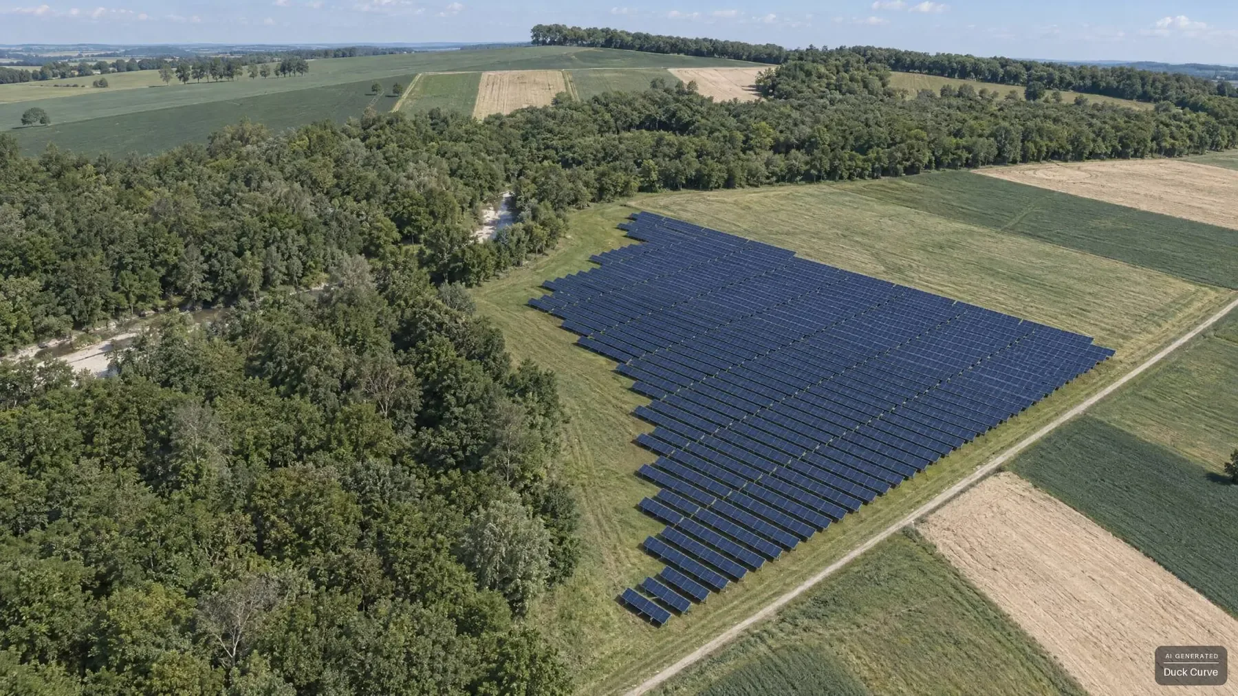
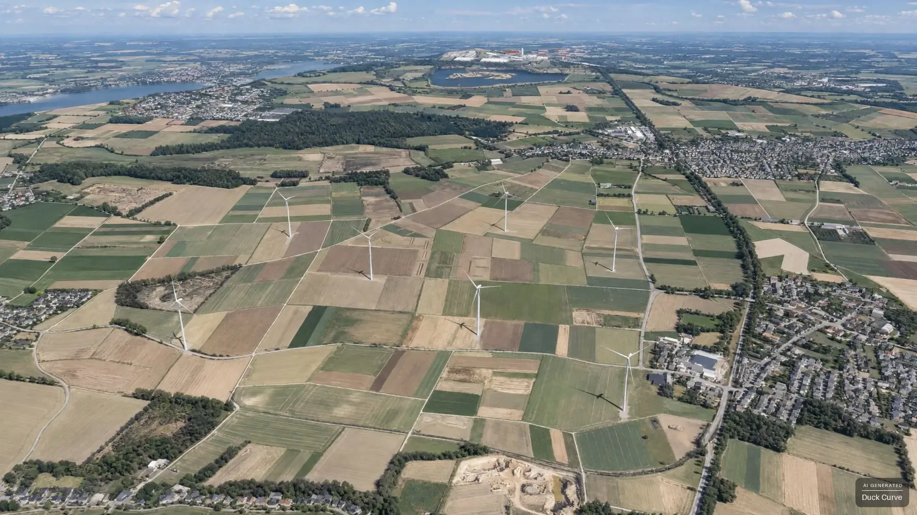
die raumansicht rendert deine planung maßstabsgetreu. daraus macht ein bildmodell eine ansicht, die aussieht wie ein foto, und zeigt damit, wie die geplante anlage auf der fläche wirken wird.the 3D view renders your layout true to scale. an image model turns this into a photo-like view that shows how the planned plant will look on the site.
die PV-planung als bildthe PV layout as an imagedieselbe fläche wie im entwurf oben, aus der raumansicht gerendert und vom bildmodell veredeltthe same site as the draft above, rendered from the 3D view and refined by the image modelbeispieldatensample datader windpark als bildthe wind farm as an imagederselbe park wie im entwurf oben, aus der raumansicht gerendert und vom bildmodell veredeltthe same farm as the draft above, rendered from the 3D view and refined by the image modelbeispieldatensample data
01
die geometrie kommt aus der planunggeometry comes from the layout
reihen, abstände und neigung stammen aus dem maßstabsgetreuen rendering. bewuchs, himmel und oberflächen setzt das bildmodell dazu und hat sie nicht gemessen. genau dieser satz steht in der anwendung unter jedem bild.rows, spacing and tilt come from the true-to-scale rendering. vegetation, sky and surfaces are added by the image model and not measured. exactly this sentence appears under every image in the application.
02
oder dein eigenes fotoor your own photo
statt der gerenderten landschaft nimmst du ein drohnen- oder straßenfoto deiner fläche. das bildmodell setzt die anlage hinein und nimmt das rendering aus ähnlicher richtung als vorlage. die landschaft bleibt dein foto, mit den echten bäumen und dem echten licht; geometrisch ist das angenähert.instead of the rendered landscape, use a drone or street-level photo of your site. the image model inserts the plant, using the rendering from a similar direction as a template. the landscape stays your photo, with real trees and real light; the geometry is approximate.
sag uns, um was für eine fläche es geht. eine KML-datei kannst du mitbringen, brauchst du aber nicht: in der demo zeichnen wir die fläche auch gemeinsam auf der karte.tell us about your site. you can bring a KML file, but you don't need one: in the demo, we can also draw the site together on the map.